

Mississippi River bridge repair work to last another year
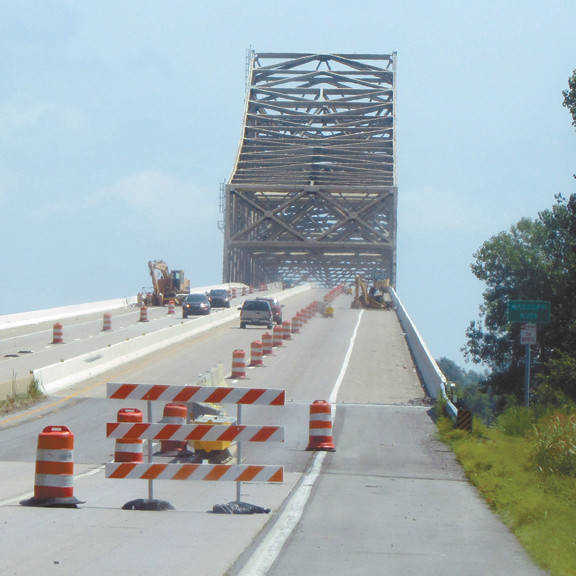
CARUTHERSVILLE - Anyone traveling west from Dyersburg on I-155 this summer has probably noticed the Mississippi River bridge is under repair, with modifications being made on both the Tennessee and Missouri sides.
Nicole Lawrence, the DOT District 4 community relations officer, said that expansion joints and navigation lights were the reasons for the repairs. She said "The project is expected to be finished by August 31, 2016 and will cost $3.2-3.3 million dollars."
An expansion joint or movement joint, according to TDOT construction requirements, "is an assembly designed to safely absorb the heat-induced expansion and cold-induced contraction of construction materials, to absorb vibration, to hold parts together, and to allow for movement due to ground settlement or earthquakes and maybe even for towboat-barge collisions.
The navigation lights will be for the heavy commercial towboat-barge traffic that passes under that bridge many times a day. That is probably a good idea considering how many towboat-barge/bridge collisions have occurred over the years. Completed in 1976, the Dyersburg-Caruthersville Bridge, according to U.S. Coast Guard records, had only six towboat collisions in the 27 years leading up till 2003. But in just the last five years, 2010-2015, there have been five major collisions, averaging one barge-bridge collision every year. No doubt the bridge's expansion joints have helped it survive the multiple impacts that have occurred.
The navigation lights, just like the red and green buoys placed by the Coast Guard, will indicate the path of the main channel and guaranteed water depth, and where under the bridge, towboats should pass. They will also indicate the bridge height above the water level, especially useful at flood stages or for tall boats, high cargo or both.
The Caruthersville Bridge is a single-tower cantilever bridge carrying Interstate 155 and U.S. Route 412 across the Mississippi River between Caruthersville, Missouri and Dyersburg.
Construction of the bridge began in February 1969 and the bridge was completed in 1976. It is the only bridge to cross the Mississippi River between Cairo, Illinois and Memphis, Tennessee, though the Dorena-Hickman Ferry also crosses the Mississippi in this area. It is also the only bridge to connect the states of Missouri and Tennessee directly. Interstate 155 connects Dyersburg (and the proposed Interstate 69) with Interstate 55 near Caruthersville, Missouri and Hayti, Missouri. U.S. Route 412, when created in 1982, was also routed across the bridge.
Below are the bridge statistics listed at: www.bridgehunter.com
* Location: River Mile 838.7.
* River Elevation: 233 Feet above sea level
* Highway: I-155 (US-412).
* Daily Road Traffic Count: 7,969 (2002).
* Bridge Type: Steel Truss Through Deck.
* Length: 7,102 Feet Overall, 1,030 Foot MO Approach Spans, 2,150 Foot Main Structure, 920 Foot and 520 Foot Main Spans, 2,480 Foot TN Approach Spans.
* Width: 78 Feet, 4 Lanes.
* Navigation Channel Width: 900 Foot Main Channel, 500 Foot 2nd Channel.
* Height Above Water: 99 Feet.
* Date Built: Opened Dec. 1, 1976.
The I-155 Caruthersville Bridge is the northernmost bridge over the Lower Mississippi River, with the combined flow of the Upper Mississippi and the Ohio River. This bridge is interesting in that it is not symmetrical. The structure on the Tennessee side is much longer than the structure on the Missouri side of the river. That is due to the bridge being located on a curve in the river, and the current is toward the outside of the curve, making the river deepest near the east bank. The U.S. Army Corps of Engineers has been working to stabilize the riverbank on the outside bank of the curve by placing rip-rap along the edge of the river channel. It is hoped that this will keep the river from migrating any further east, possibly bypassing the bridge.
The Caruthersville Bridge sits in a geologically interesting place in that it is only 6 miles from the New Madrid Fault. A 1993/1994 study found that bedrock was located 2700 feet under the surface, so a significant earthquake event would almost certainly create severe liquefaction. The bridge as it stands would not hold up to liquefaction.